Photo by Birmingham Museums Trust on Unsplash
The lost settlement of Streetway
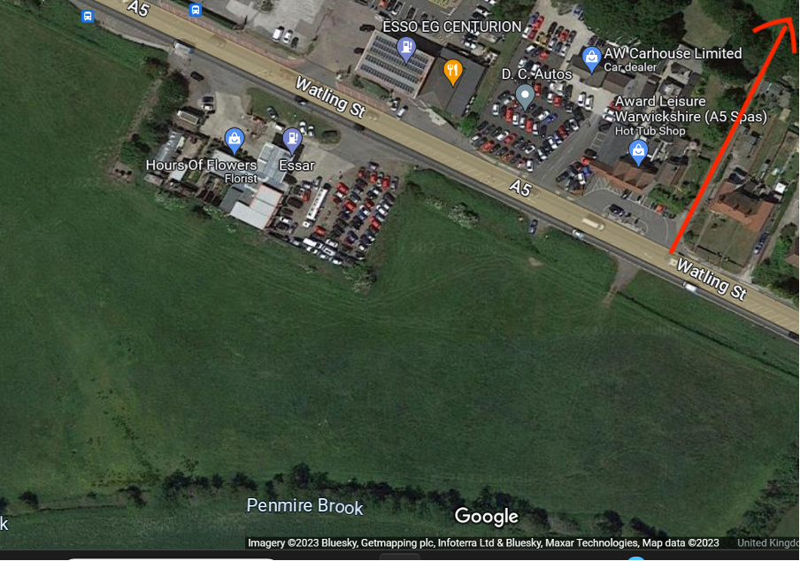
Have you ever wondered why there is a footpath leading from the Watling Street, opposite a field?
In fact, the footpath leads up from the Watling Street, then over Dunns Lane and down into Polesworth; this latter part of the path is known as the ‘Coffin Trail’.
The whole of this footpath is actually a real coffin trail and a pathway that lead to Polesworth from a now deserted and demolished settlement called ‘The Streetway’. This trail would have been the quickest way to walk to Polesworth Abbey for services - and particularly for funerals.
The whole of this footpath is actually a real coffin trail and a pathway that lead to Polesworth from a now deserted and demolished settlement called ‘The Streetway’. This trail would have been the quickest way to walk to Polesworth Abbey for services - and particularly for funerals.
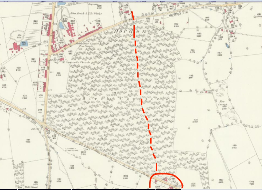
This 1885 OS map (Copyright National Library of Scotland) shows the footpath going up through the woods to join with the path down to Polesworth Common. As you can see, by this point there is only one small building remaining of Streetway, where there used to be a whole settlement.
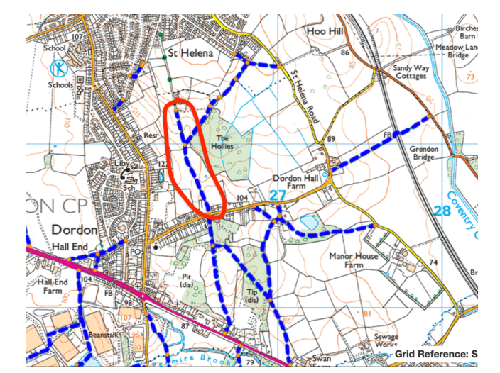
On this map the coffin trail follows a straight line down to the Watling Street. The area we now call the ‘Coffin Trail’ is circled in Red.
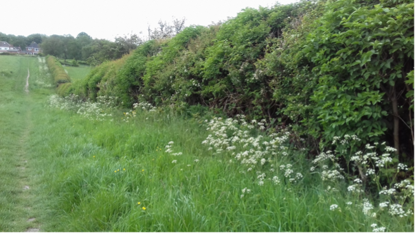
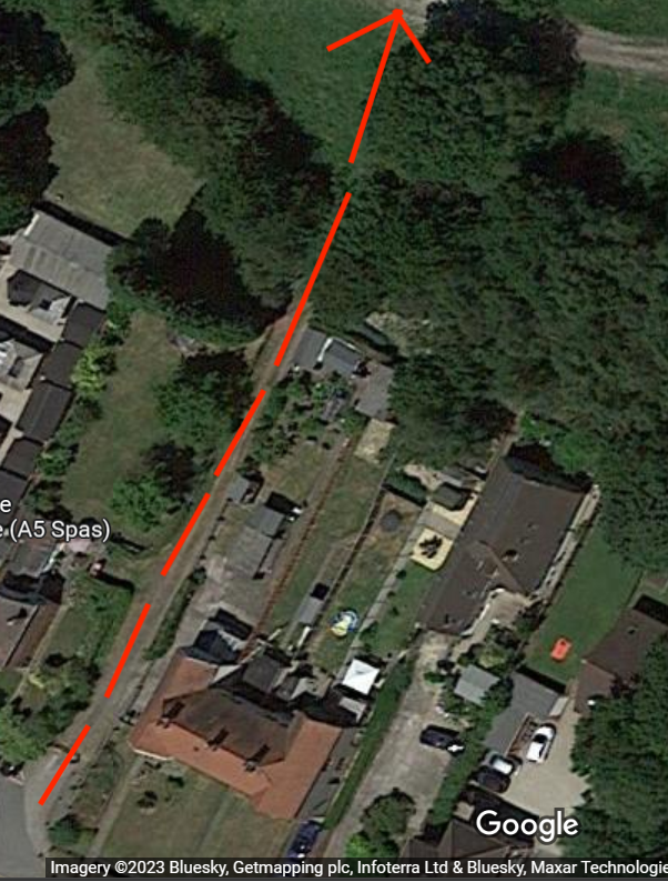
The coffin trail as we know it today, with its historic hedgerow.
How do we know Streetway existed?
Streetway is mentioned in Hearth Tax returns from the 17th Century; also in the church registers from St Editha’s, Polesworth.
What was the Hearth Tax?
The Hearth Tax was a way of earning extra revenue from the wealthier in society. Charles II reintroduced this tax in 1662. On May 19th, 1662, the Hearth Tax became law. It was intended to create a revenue to support the Royal Household. It lasted for 27 years until it was repealed by King William III and Queen Mary. Every homeowner or occupier was asked to pay two shillings a year per hearth or stove they had in their property. The tax was collected twice a year, on Lady Day (March 25th) and Michaelmas (29th September).
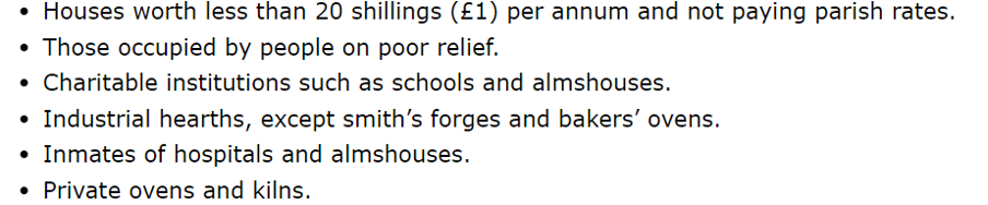
The following exemptions were allowed:
How do we know Streetway existed?
Streetway is mentioned in Hearth Tax returns from the 17th Century; also in the church registers from St Editha’s, Polesworth.
What was the Hearth Tax?
The Hearth Tax was a way of earning extra revenue from the wealthier in society. Charles II reintroduced this tax in 1662. On May 19th, 1662, the Hearth Tax became law. It was intended to create a revenue to support the Royal Household. It lasted for 27 years until it was repealed by King William III and Queen Mary. Every homeowner or occupier was asked to pay two shillings a year per hearth or stove they had in their property. The tax was collected twice a year, on Lady Day (March 25th) and Michaelmas (29th September).
The following exemptions were allowed:
Exemption certificates had to be signed by two JPs.
Even if the occupier was too poor to pay, their names were written on the hearth tax records. This gives us a good idea who was living in Streetway in this period.
Fortunately, the records for this part of Warwickshire have survived and have been studied.
How do we know where it was?
In Staffordshire Records Office there is an estate map for Dordon and Grendon (ref: D1176/A/39/11) dating to 1722. From this, together with the fact that the Hearth Tax documents stated that the houses were close to the Watling St, we can identify the site. The map names some of the tenants at the time and these match the church records.
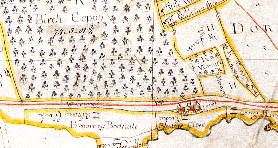
Part of the 1722 map showing the small settlement of Streetway (just below the A, H and N next to the Watling St).
We know that the original village of Dordon, which contained 'The Streetway' was on the eastern side of what is now Long St, as the west of Long St was known as Hall End and classed as a different hamlet. The church records clearly state 'Streetway, Dordon'.
The A H and N in the map above tell us you who was the tenant of the properties there:
A - John Baxter
H - Widow Garbidge (sometimes spelled Garbage)
N - Thomas Johnson
In fact, the land around was known as Baxter’s Close.
What is the earliest known date for the settlement?
The first mention of Streetway in the Parish Records of Polesworth, St Editha’s, is of a baptism of John, Son of Thomas Becke, on 10th July 1642. This suggests that Streetway was well established and known by this point.

It reads July 10th John son of Thomas Becke of the Streetway in Dordon baptized.
Who Lived there?
The Parish records list some of the people who lived at Streetway. Some of the surnames can still be found in the area today and these could be direct descendants!
Surnames of the residents of Streetway
Ashbishaw
Baxter
Beck or Becke
Child
Garbage or Garbidge
Glent
Harper
Hinks
Mason
Mellis
Mills
More
Osman
Payne
Porter
Smith
Snow
Spencer
Tallis
Wainwright
Wall
What do we know about the people who lived here?
Sometimes the parish registers give extra information about the individual; for example, in one of the baptism records for 11th December 1704, of 'Mary daughter of Robert Snow', she is described as “a bastard”. Usually the father’s name in such cases is not known, however in this case Robert must have formally recognised the child as his own.
Quite often burial records have extra comments; for example John Bates, a Minister from Over Whitacre, died there on 10th December 1670 - presumably he was visiting when he died.

Sometimes the person’s status or age were mentioned; for example on the 10th March 1674 widow Smith was buried - she is described as “old”.
On 30th November 1685 Jane Tallis was buried, and described as “A poore Maide”, suggesting a poor unmarried woman.
On 30th November 1685 Jane Tallis was buried, and described as “A poore Maide”, suggesting a poor unmarried woman.

Mining at Streetway
At this time the vast majority of Dordon was owned by the Chetwynd family who had one of their residences at Grendon Hall. If you leased the land from the Chetwynd Estate, you had the rights to the timber on the land, you had the right to farm it, and more importantly you had the right to mine any seams crossing your land.
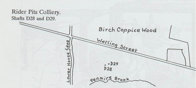
From Coal Authority records and the research carried out by Lawrence Fretwell, we know that there were 4 shafts in Streetway. Two were known as the 'Old Rider Pits' (Coal Authority ref EM1081).
At this time the vast majority of Dordon was owned by the Chetwynd family who had one of their residences at Grendon Hall. If you leased the land from the Chetwynd Estate, you had the rights to the timber on the land, you had the right to farm it, and more importantly you had the right to mine any seams crossing your land.
From Coal Authority records and the research carried out by Lawrence Fretwell, we know that there were 4 shafts in Streetway. Two were known as the 'Old Rider Pits' (Coal Authority ref EM1081).
Copyright L Fretwell
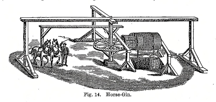
Perhaps something like this horse-driven mechanism may have been used at the Old Rider Pits
From records showing where the Chetwynd collieries were, we know that the mines had closed by 1770.
There were two more shafts discovered in 1955 when some of this area had open cast mining. Two square 5ft by 5ft timber-lined shafts were found. According to Fretwell, it is likely that the mine used waterpower from the Sugar Brook, as bricks were found dating from this period suggesting the site of a waterwheel. Open casting diverted the Penmire Brook so it no longer meets the Sugar Brook.
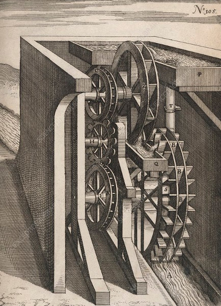
The wheel might have looked a bit like this.
By 1770 mining from these shafts had finished.
Mines discovered in 1955 during opencasting.
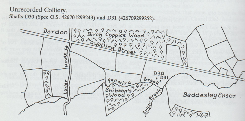
Copyright L Fretwell
A closer look at some of the people who lived in Streetway
Widow Ashbishaw
On the 14th May 1673, George, the Widow Ashbishaw’s son, was baptised at Polesworth. Sadly, George Ashbishaw, the child’s father, had been killed in a “Coalpit” on the 10th April, the month before. Before his death, the family had lived at Freasley and according to the records George and his family had paid Hearth Tax on one Hearth. George senior had been married before and had grown up children who seem to have continued to live at Freasley; but the second wife seems to have moved out to live in Streetway.
The Garbage (Garbidge) family
From the parish records we know that at least two generations of the Garbage family lived at Streetway. The first mention is in 1661, when John, son of John Garbage, was baptised on 15th December. John senior went on to have four more children baptised at Polesworth, the youngest being Ann on the 6th July 1679. On 13th February 1682 John Junior of Streetway married Elizabeth Pickering at Polesworth. Either John senior remarried, or John junior had been married before, as Grace, widow of John Garbage, was recorded as being buried on 12th November 1681, four days after their stillborn twins. John and Elizabeth also had a son called John and it is probably his widow who is mentioned on the 1772 map. John Garbage senior is mentioned in the Hearth Tax records, but does seem to have had an exception certificate for 1666, 1672 and 1674, so perhaps he was less prosperous at this time - or just more persuasive in successfully getting a certificate!
Thomas More
In the burial registers Thomas Moore from Streetway was buried on 1st November 1706; he is described as being “old”. We do know he had a son baptised, also called Thomas, on April 26th 1668 but it is unclear when Thomas senior was born. During the civil war, Thomas senior was forced to accommodate Scots soldiers who were allied to the Parliamentary army, and later claimed £2 8s and 2d in compensation as they had taken amongst other possessions; 5 shillings in money, 3 shirts, 3 hens and a cockerel - and at another time 3 shillings and 2 ewes were taken from his son. In total, residents in Dordon claimed £14 17 s, which suggests that the Moore family were relatively wealthy to have lost so much. The loss accounts for Dordon and North Warwickshire are now available online and make fascinating reading (Warwickshire Civil War loss accounts – Heritage and culture).
The Baxter Family
When looking at Streetway, one family name dominates. The first mention of Baxters living at Streetway is when John Baxter is charged with Hearth Tax in 1664. There is a record of his daughter Mary being baptised on 11th August 1667. The Baxters seem to have been tenants on the land surrounding the area and were farming it and probably involved in mining. Two burial entries suggest this - firstly an entry from 1684 reads:
2nd July 1684 William Baxter was killed with the falling off a cart as he was loading hay. He was buried in Streetway.
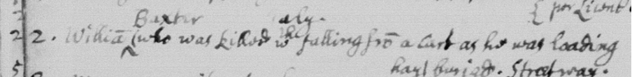
Entry in the parish burial book.
Secondly, an entry for 6th June 1706 records that Richard, the son of Widow Baxter, was killed in a Coalpit by a fall of earth.
Richard may not have been working as a Miner, although as the mines were probably still working at this point it is likely he died whilst working.
Secondly, an entry for 6th June 1706 records that Richard, the son of Widow Baxter, was killed in a Coalpit by a fall of earth.
Richard may not have been working as a Miner, although as the mines were probably still working at this point it is likely he died whilst working.
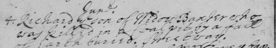
Entry from the parish burial book.
We know that the Baxters were still living in Streetway in the 1780s, as a Mary Baxter, daughter of John and Ann Baxter, was baptised on 17th August 1788 and their residence was recorded as Streetway.
The 1850 map shows the site of where Streetway was (no 178) with possibly a building or two.
We know that the Baxters were still living in Streetway in the 1780s, as a Mary Baxter, daughter of John and Ann Baxter, was baptised on 17th August 1788 and their residence was recorded as Streetway.
The 1850 map shows the site of where Streetway was (no 178) with possibly a building or two.
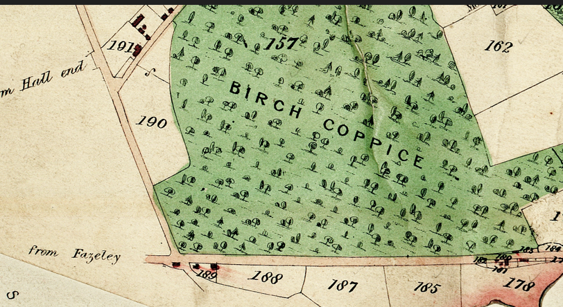
The area was still known as Baxter’s Croft, but now consisted of meadows farmed by John Pittman.
What happened to Streetway?
After being quite a thriving area in the 17th and 18th centuries, people appear to have moved away from the settlement. Although the Baxters were still living there and were farming the area - hence the name “Baxter's croft” in the very late 1700s, they had moved by 1850. From the parish records, we know that the last record for Streetway as a site of occupation was August 1788 - when not only Mary Baxter, but also George Wainwright was baptised, on the 31st August 1788. George was the son of William and Mary Wainwright. Children from the Payne and Spencer families were also baptised in the 1770s and recorded as living at Streetway. Most likely people moved away for work. We know that the mines had been closed before 1770, leaving only agriculture as a way to make a living. Four shafts had been worked in this area for at least 150 years, as well as the land being farmed, with the likelihood of at least one working waterwheel there. Finally the site was converted into meadowland, with few clues left on the surface to suggest what was there before.